About Elevation Map-Mountain Weather
As the altitude increases, the air becomes thinner, the temperature decreases, the air pressure decreases, the boiling point of water decreases, the oxygen content in the air decreases, and the oxygen partial pressure...
As the altitude increases, the air becomes thinner, the temperature decreases, the air pressure decreases, the boiling point of water decreases, the oxygen content in the air decreases, and the oxygen partial pressure decreases. When we climb higher mountains or go to high altitude areas, this knowledge is what we need to know.
Elevation Map-Mountain Weather app uses the relationship between altitude and air pressure, air temperature, and oxygen, and uses altitude to calculate air pressure, air temperature, and oxygen or calculate altitude by air pressure. At last, the app provide mountain weather forecast for 7178 mountains in the world.
According to the oxygen-hemoglobin dissociation curve, healthy people can maintain normal blood oxygen saturation at an altitude of 3000 meters or even 4000 meters and 5000 meters. However, when the pH drops, the body temperature rises or other reasons will reduce the oxygen affinity, the blood oxygen saturation will drop to an abnormal range at this altitude, causing hypoxia. The app simulates the dissociation curve to help users analyze the influence of body temperature and PH on blood oxygen saturation, and predict blood oxygen saturation at different altitudes.
The Elevation Map-Mountain Weather app provides global elevation data, which can be queried on the map or by input longitude and latitude value. Under the query results, you can set the sea level temperature and air pressure to calculate the air pressure, air temperature, boiling point, oxygen content, oxygen partial pressure, and blood oxygen saturation at the elevation. An elevation color map is also provided to visualize global elevation distribution.
The Elevation Map-Mountain Weather app is divided into the following five parts:
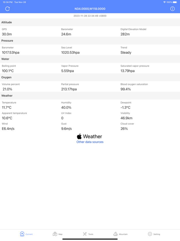
1. Current:
Combining GPS, device barometer, and real-time weather at the current location, get the current location's altitude, air pressure, water boiling point, oxygen content and blood oxygen.
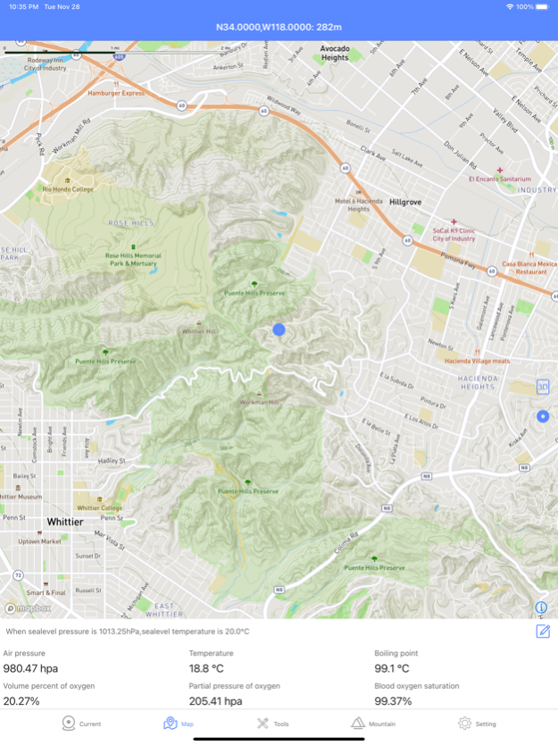
2. Map:
Move the map to get the elevation of any location, and calculate the air pressure, air temperature, boiling point, oxygen content, blood oxygen of the location given the sea level air pressure temperature combined with the altitude
3. Tools:
The tool part mainly has 6 functions:
1. Elevation search
2. Altitude list
3. Altitude calculate
4. Oxygen-hemoglobin dissociation curve
5. Blood oxygen log
6. Elevation Color Map
4. Mountain
Favorite mountain and mountain weather forecast at different elevation。
Disclaimer:(Mountain weather forecast)
This application is not dedicated to predicting various sudden weather disasters in mountainous areas. It mainly informs about meteorological factors that always exist and change with altitude, such as temperature, air pressure, humidity, oxygen content, etc. IN NO EVENT SHALL THE APP BE LIABLE FOR ANY CONSEQUENTIAL, SPECIAL, LOST PROFITS, INDIRECT OR OTHER DAMAGES. When conducting such activities, please choose a more accurate, more specific, and more comprehensive forecast plan
5. Settings
【Pro】
1.Mountain weather forecast
2.unlock all tools
Purchase rules:
[Month Pro] Purchase a monthly member for $ 2.99 / month and renew it automatically every month.
[Annual Pro] 19.99 $ / year to purchase annual annual membership and automatically renew it annually.
Purchase Notes:
1. The account will be automatically renewed and deducted the corresponding fee 1 day before the expiration.
2. If you need to cancel the renewal, please cancel in your personal iTunes account at least 1 day in advance.
3. After purchase, users can manage or turn off automatic renewal in personal account settings.
Terms of Services :
https://www.astronomyobserver.net/h5/elevation/user/en
Privacy policy:
https://www.astronomyobserver.net/h5/elevation/privacy/en
Feb 28, 2024
Version 2.8
download digital elevation model
Previous Versions
Here you can find the changelog of Elevation Map-Mountain Weather since it was posted on our website on 2024-01-11 09:09:32.
The latest version is 2.8 and it was updated on 2024-04-19 20:13:32. See below the changes in each version.
Elevation Map-Mountain Weather version 2.8
Updated At: 2024-02-28
Changes: Feb 28, 2024
Version 2.8
download digital elevation model
Elevation Map-Mountain Weather version 2.6
Updated At: 2023-12-19
Changes: Dec 19, 2023
Version 2.6
Add sunrise sunset time at different elevation of mountain
Disclaimer
Official App Store Link
We do not host Elevation Map-Mountain Weather on our servers. We did not scan it for viruses, adware, spyware or other type of malware. This app is hosted by Apple and passed their terms and conditions to be listed there. We recommend caution when installing it.
The App Store link for Elevation Map-Mountain Weather is provided to you by apps112.com without any warranties, representations or guarantees of any kind, so access it at your own risk.
If you have questions regarding this particular app contact the publisher directly. For questions about the functionalities of apps112.com contact us.